
Lawrence Neighbors Block Sources
The public record around a Lawrence address is a set of separate layers. The parcel map supplies geometry for a parcel, the mapped land record tied to an address, and a route to assessment data. The assessor card may identify an owner, mailing address, physical parcel address called the situs, parcel identifier, and tax context. A deed is a recorded land transaction. The local annual register is a civic record with protected exceptions. A reverse directory is a dated historical listing. Association material is a public contact and meeting layer, not a membership file. Keep the source date and the relation to the block beside every result.
| Source | What It Shows About a Block | Access |
|---|---|---|
| Lawrence MIMAP GIS | Parcel geometry, street segment, map labels, and links to assessment data. | Public viewer through the Lawrence Assessor page; live controls need verification. |
| VGSI assessor | Owner, mailing address, physical parcel address, value, tax, and parcel-card context. | Public online and Assessor Room 103; owner is not automatically an occupant. |
| Northern Essex deeds | Recorded parties, legal descriptions, plans, and transaction dates for adjacent lots. | Registry online and counter; images begin in 1869 and indexes have limits. |
| Lawrence annual register | Available public voter names, residences, party, and status fields for the requested local record. | Election Division request; protected entries stay withheld. |
| Reverse directories | Historic occupants in address order and dated street-by-street snapshots. | Library Special Collections, archives, and selected reference holdings. |
| Neighborhood associations | Published contacts, meetings, public activities, and neighborhood context. | City page and public flyer; not a resident or membership roster. |
These records should not be merged into a single label. A mailing address is where tax correspondence goes. The situs is the physical parcel address. A deed party is part of a land transaction. A directory occupant is tied to a particular publication year. A voter record has its own date and access limits. A result from one source may support a useful question, but it does not prove every other connection to the block.
Map a Lawrence Block Outward
The City describes MIMAP as a public GIS and assessment-data resource, but the official static pages do not provide a stable viewer URL or a complete live control list. Open MIMAP from the Assessor page, search or locate the target address, and confirm the displayed parcel before using it as a map reference. A parcel boundary is not a building outline, a household boundary, or a city-limit line. The map is a navigation aid that points to the record card and the deed or plan identifiers needed for a more careful block comparison.
Address-to-parcel flow: target street address → selected parcel polygon → parcel or account identifier → linked assessor card → adjoining parcel polygons → deed or plan references → same-year directory or public civic context.
- Record the target address exactly as displayed, along with the parcel or account identifier and map date if shown. Keep the physical situs apart from any owner mailing address.
- Select the target polygon, then pan or click parcels that share the street segment or a boundary. Record adjacent parcel identifiers rather than assuming a map label identifies a person.
- Open each linked assessor card and record its owner field, mailing field, situs, and deed reference with a source date. A current card may reflect a different update cycle than the Registry.
- Use the Registry deed or plan reference to compare recorded lot descriptions and transaction dates. Stop when a lot is merged, divided, restricted, or its legal description changes.
Do not claim a MIMAP tool or layer that has not been verified on its live screen. The research located address search, parcel selection, map browsing, and assessment linkage as the documented method. Exact layer toggles, buffer controls, historical coverage, and a permanent viewer URL remain unconfirmed and should not be filled in from a guess.
Lawrence Owners and Occupants
An owner field answers an ownership question. It may identify an individual, trust, estate, or entity connected to the parcel, but it does not show who is present at that address. The assessor's mailing address is an administrative destination, not proof of physical occupancy. A deed shows the grantor, or seller, and grantee, or buyer, document roles, the recording date, legal description, meaning the deed's lot or plan identifier, and book, page, or instrument number. It is not a neighborhood household list. A multi-owner parcel or entity-owned parcel needs its own instrument and entity review rather than a guess about one person.
Use neutral relation labels in a block note: recorded owner, tax mailing destination, current parcel relation, dated directory listing, public voter residence, or unverified lead. Keep a separate line for a conflicting name or address instead of silently choosing one. A permit applicant can be an owner, contractor, designer, or another authorized party, so it also needs a record-specific label. That discipline prevents the public parcel layer from becoming a claim about every Lawrence neighbor.
Note: Owner, mailing, and situs fields can update at different times, so record the source date before comparing any of them.
Lawrence Voter Records Aren't Census
Massachusetts local voter records can have public fields such as name, address, party, date of birth, active or inactive status, voter ID, registration date, and dated voting or change information where permitted. The Lawrence City Clerk and Board of Registrars maintain the local route. Request a stated annual register, street list, voter list, or election record with the year, ward or precinct, and preferred paper or electronic format. The local annual register can be a useful dated layer for a block, but it is not a census of everyone at nearby addresses.
Phone and email, veteran status, permanent-absentee status, confidential records, protected voters, and minor records are not ordinary public fields. The statewide central registry is not a public record under M.G.L. c. 51 § 47C, even though local lists can be available through the proper custodian. The individual state voter-status form is for a person's own status and requires name, full date of birth, residential ZIP, and agreement. It is not a public block-search form.
Lawrence Neighborhood Associations
Lawrence's association layer is a public community route, not a City department or a list of residents. The City says its Community Development work supports grassroots associations through capacity building, partnerships, event coordination, grant writing, incorporation, group development, and training. Public meetings and published contacts can help someone understand neighborhood boundaries, history, or a civic concern. They do not establish that a particular person belongs to the group or authorizes disclosure of membership.
| Association | Officially located public detail | Appropriate use |
|---|---|---|
| Colonial Heights | Listed in the Lawrence Neighborhood Association Partnership flyer with a meeting pattern. | Use the published public meeting route; verify current scheduling. |
| South Common Central | Flyer reports a fourth-Tuesday public meeting pattern. | Community context and public meeting information only. |
| South Lawrence West | Flyer reports a second-Monday public meeting pattern. | Confirm dates through the published association contact. |
| District A | City page lists a public meeting pattern and contact route. | Use the City association page for current details. |
| Mount Vernon | City page reports meetings three times each year. | Ask for public meeting or newsletter information. |
| Tower Hill | City page reports a monthly public pattern except July and August. | Do not infer membership from a nearby address. |
Lawrence's Neighborhood Associations page is the official starting point for the City's public association and community-support route.
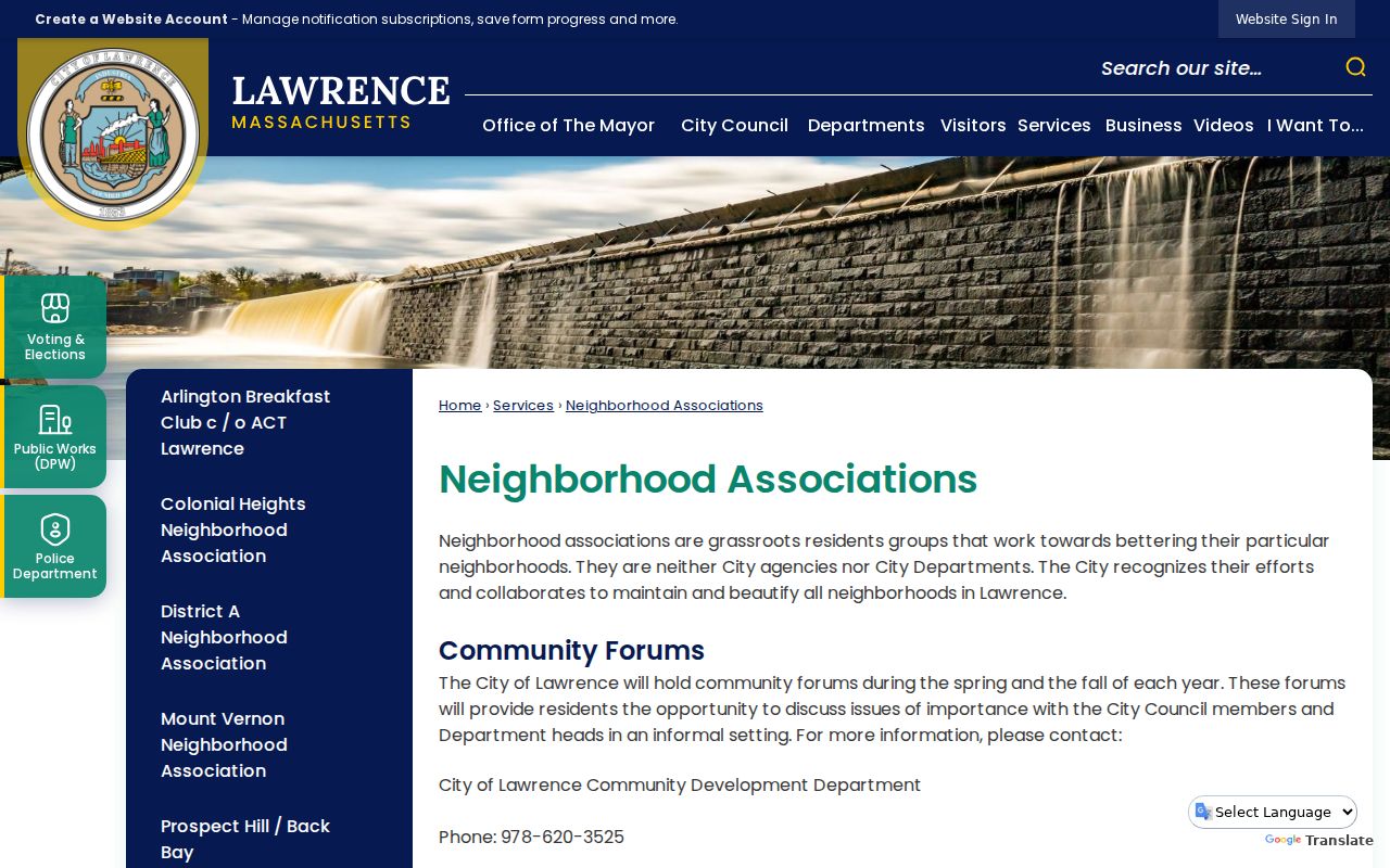
The public page supports civic contact and public forums, while member and household information remains private.
Lawrence Community Contacts
The Lawrence Neighborhood Association Partnership flyer names additional public community routes, including Arlington Breakfast Club or ACT Lawrence and Prospect Hill or Back Bay in the City site map. LNAP acts as an umbrella partnership for strengthening associations, but it is not a city agency and no universal association roster is published. A public meeting can be a better route for neighborhood history than a broad name search. Ask about a current meeting, newsletter, public event, or archival material rather than asking an association to identify people nearby.
Boundaries also need separate labels. A parcel sits in municipal assessment geography. A voter record uses a residence and may have ward or precinct context. A postal ZIP, court division, Registry district, and association area can all overlap without matching. Lawrence's Northern Essex Registry district also serves Andover, Methuen, and North Andover, so a Registry result needs its own town and legal-description check before it is included in a Lawrence block history.
Note: Public association contacts can explain a neighborhood, but they cannot confirm a person's membership, address, or private household connection.
Past Lawrence Neighbors by Directory
For an earlier block, use a reverse or house-guide directory before applying a modern parcel label. Selected Massachusetts State Library holdings cover reverse directories from 1915 through 1969, while broader Lawrence city-directory bibliography reaches 1847 through 1980 with gaps that need confirmation. A reverse directory can place a name at an address in a specific year, but it remains a printed snapshot. Preserve the directory title, publisher, year, page, section, printed street spelling, number, and any occupancy notation exactly as published.
Lawrence Public Library Special Collections holds city directories and Eagle Tribune microfilm as non-circulating local-history material, with readers available in the building. Pair a directory year with newspapers, city reports, cemetery records, probate, deed descriptions, or a same-year reverse section when appropriate. Historical street numbers and names can differ from current use, so keep the printed form beside a later normalized address. The City Directories collection provides the wider shelf and date context for this kind of block research.
Compare Lawrence Block Sources
Official records and commercial neighbor-lookup categories have different roles. Official sources identify their custodian, record date, and scope, even when they are incomplete or restricted. Commercial services can combine brokered addresses, marketing data, public-record matches, user-submitted material, and older files. Those compilations can conflate people with the same name or preserve an address after it no longer reflects the underlying record. A commercial result should never replace a Lawrence assessor card, Registry image, local voter request, library directory, or documented association contact.
| Source category | Strength | Boundary |
|---|---|---|
| Official parcel, Registry, voter, and City records | Named custodian, defined record type, and source date. | May be limited, historical, protected, or unrelated to occupancy. |
| Library directories and public association materials | Dated historical listing or a published public contact route. | Not a current residence claim or a member roster. |
| Commercial neighbor-lookup category | May suggest a record to verify with the original custodian. | Can be stale, brokered, conflated, or incomplete; do not treat it as authoritative. |
When sources conflict, save both results with their dates and roles. A current assessor mailing field should not overwrite a historical directory entry, and an association name should not be used to fill a missing parcel or household field. Search the narrowest record that answers the question, then report the exact limitation of the result.
Lawrence Records Office Fallbacks
Online search does not replace a custodian when a year, field, or image is missing. The Assessor can clarify a parcel card or assessment record, while the Northern Essex Registry counter can help route a book, page, instrument, plan, or legal-description search. The Election Division is the local channel for an annual register or specific voter-record request. Library Special Collections and the Lawrence History Center are the better fallbacks for offline directories, newspapers, maps, and local collections. Ask for the exact series, date range, access method, and any fee before assuming a record is available.
Massachusetts public-records request guidance supports electronic, mail, and in-person requests to the responsible custodian. A written request should identify one department, one record family, a date range, a preferred format, and a fee ceiling or request for an estimate. A request for every record about nearby people is too broad. Written responses, fee estimates, production dates, and cited exemptions should stay with the search notes.
Note: A missing online result may mean no match, a restricted record, a different custodian, or an unindexed offline series.
Limits on Lawrence Neighbors
Non-owner household members, utility customer data, delivery records, DMV addresses, protected voter information, actual ACP addresses, sealed or impounded court material, juvenile records, and private association membership are not a public block directory. Massachusetts Address Confidentiality Program participants use a substitute address that must not be reverse-engineered from older property, voter, court, or directory clues. The public availability of a record image does not authorize repeating sensitive identifiers or protected location information.
Use the most limited record needed for a lawful personal question, such as block history, community context, family research, or civic curiosity. If a public record appears inaccurate, protected, or in need of redaction, contact the issuing custodian, the voter-protection process, ACP, or the court's impoundment process. Do not publish a protected address or use repeated record searching to watch, pressure, harass, or intimidate anyone.
Lawful use. Use Lawrence neighbors records for personal, lawful research and public community context. Never use a record to stalk, harass, intimidate, or expose a protected person or address.